
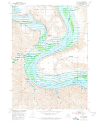
1952 Map of Iona NW
USGS Topo · Published 1955About this map
The confluence of the White River and the Missouri River dominates this mid-century landscape along the border of Lyman and Brule Counties. This survey documents the river valley before the rising waters of the Fort Randall Reservoir altered the shoreline, as indicated by the blue submerged area lines. The topography transitions from the alluvial plains of Peterson Bottoms to the dissected bluffs of the Oacoma and Iona districts. Evidence of rural life is concentrated in localized ranching complexes such as Close Ranch and Glaus Ranch, while the presence of the Walker Sch and the Grandview Sch (Abandoned) marks the shifts in local education and settlement. The land is punctuated by numerous Flowing Wells, vital for sustaining operations across this river-basin terrain.
Find a feature on this map
21 named features on this map. Tap any name to fly to it.
Don’t see what you’re looking for? This feature index may not catch every label — zoom into the map to look around manually.
Map Details
Editions of this 1952 Iona NW Map
2 editions found
Other maps of this area

1935 · Chamberlain
USGS Topo · 1:62,500

1939 · Chamberlain
USGS Topo · 1:62,500

1940 · Iona
USGS Topo · 1:62,500

1944 · Iona
USGS Topo · 1:62,500

1952 · Reliance SE
USGS Topo · 1:24,000

1952 · Hamill NE
USGS Topo · 1:24,000

1952 · Oacoma
USGS Topo · 1:24,000

1955 · Mitchell
USGS Topo · 1:250,000

1959 · Mitchell
USGS Topo · 1:250,000

1971 · Hamill SE
USGS Topo · 1:24,000