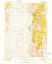
1950 Map of Ione
USGS Topo · Published 1950About this map
The high desert terrain of the Toiyabe National Forest dominates this mid-century survey, revealing a landscape defined by Nevada's mining history. The settlement of Ione serves as a primary point of reference alongside the mining camps of Berlin and Grantsville. The map documents the industrial footprint of the era, from the Nevada Cinnabar Mine and Shamrock Diggings to the Kohinoor Mine, which is specifically noted as inactive by the late 1940s. Natural features such as Buffalo Mtn and Grantsville Ridge dictate the placement of early infrastructure and ranching outposts like Milton Ranch. The prevalence of named springs, including Indian Garden Spr and Wild Carrot Spr, highlights the critical importance of water sources for both the survival of these high-altitude settlements and the processing operations of the local mines during the post-war period.
Find a feature on this map
34 named features on this map. Tap any name to fly to it.
Don’t see what you’re looking for? This feature index may not catch every label — zoom into the map to look around manually.
Map Details
Editions of this 1950 Ione Map
2 editions found
Other maps of this area

1907 · Tonopah
USGS Topo · 1:250,000

1908 · Tonopah
USGS Topo · 1:250,000

1948 · Paradise Peak
USGS Topo · 1:62,500

1948 · Ione
USGS Topo · 1:62,500

1950 · Paradise Peak
USGS Topo · 1:62,500

1950 · Ione
USGS Topo · 1:62,500

1955 · Millett
USGS Topo · 1:250,000

1956 · South Shoshone Peak
USGS Topo · 1:62,500

1956 · North Shoshone Peak
USGS Topo · 1:62,500

1956 · Tonopah
USGS Topo · 1:250,000