
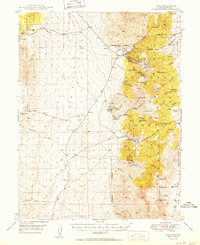
1950 Map of Ione
USGS Topo · Published 1950About this map
Ione and Berlin anchor this mid-century look at the western edge of the Toiyabe Range, where mining history and high-desert ranching intersect. The landscape is defined by the steep elevation of Buffalo Mtn and Knickerbecker Ridge, cut by drainage systems like Ellsworth Canyon and Ione Canyon. Evidence of the region's mineral industry is prominent, with the Kohinoor Mine, Shamrock Mine, and the Nevada Cinnabar Mine scattered across the slopes. Near Grantsville, the presence of a Cem and Milton Ranch highlights the small pockets of permanent settlement and agriculture maintained in this arid environment. This 1950 survey, based on 1946 aerial photography, provides a detailed view of the trail and spring network—including Ione Spring and Spanish Spr—essential for survival and commerce in this section of the Toiyabe National Forest.
Find a feature on this map
53 named features on this map. Tap any name to fly to it.
Don’t see what you’re looking for? This feature index may not catch every label — zoom into the map to look around manually.
Map Details
Editions of this 1950 Ione Map
2 editions found
Other maps of this area

1907 · Tonopah
USGS Topo · 1:250,000

1908 · Tonopah
USGS Topo · 1:250,000

1948 · Paradise Peak
USGS Topo · 1:62,500

1948 · Ione
USGS Topo · 1:62,500

1950 · Paradise Peak
USGS Topo · 1:62,500

1955 · Millett
USGS Topo · 1:250,000

1956 · South Shoshone Peak
USGS Topo · 1:62,500

1956 · North Shoshone Peak
USGS Topo · 1:62,500

1956 · Tonopah
USGS Topo · 1:250,000

1959 · Tonopah
USGS Topo · 1:250,000