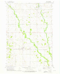
1972 Map of Ionia
USGS Topo · Published 1976About this map
The Wapsipinicon River and its tributary, the Little Wapsipinicon River, dominate the terrain of Chickasaw County in this early 1970s survey. The village of Ionia is positioned along the Chicago Milwaukee St Paul and Pacific railroad line, serving as a focal point for the surrounding agricultural townships of Deerfield, Washington, Chickasaw, and Dayton.
Find a feature on this map
22 named features on this map. Tap any name to fly to it.
Don’t see what you’re looking for? This feature index may not catch every label — zoom into the map to look around manually.
Map Details
Editions of this 1972 Ionia Map
This is the sole edition of this map. No revisions or reprints were ever made.
Other maps of this area

1954 · Mason City
USGS Topo · 1:250,000

1954 · Waterloo
USGS Topo · 1:250,000

1955 · Waterloo
USGS Topo · 1:250,000

1957 · Mason City
USGS Topo · 1:250,000

1958 · Mason City
USGS Topo · 1:250,000

1971 · Tripoli NW
USGS Topo · 1:24,000

1971 · Frederika
USGS Topo · 1:24,000

1971 · Bassett
USGS Topo · 1:24,000

1971 · Colwell
USGS Topo · 1:24,000
1971 · Nashua
USGS Topo · 1:24,000