
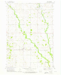
1971 Map of Colwell
USGS Topo · Published 1973About this map
The Colwell town site and the surrounding agricultural landscape of Floyd, Mitchell, Chickasaw, and Howard counties are documented here in the early 1970s. This survey records a transition in rural transport, clearly marking the path of the Old Grade Railroad cutting through the fields south of the main settlement. The terrain is defined by the winding course of the Wapsipinicon River and the Little Cedar River, which feed into the local drainage system alongside Beaver Creek.
Find a feature on this map
21 named features on this map. Tap any name to fly to it.
Don’t see what you’re looking for? This feature index may not catch every label — zoom into the map to look around manually.
Map Details
Editions of this 1971 Colwell Map
This is the sole edition of this map. No revisions or reprints were ever made.
Other maps of this area

1954 · Mason City
USGS Topo · 1:250,000

1957 · Mason City
USGS Topo · 1:250,000

1958 · Mason City
USGS Topo · 1:250,000

1971 · Charles City
USGS Topo · 1:24,000

1971 · Bassett
USGS Topo · 1:24,000

1971 · Floyd
USGS Topo · 1:24,000

1972 · New Haven
USGS Topo · 1:24,000

1972 · Riceville
USGS Topo · 1:24,000
1972 · Ionia
USGS Topo · 1:24,000

1972 · Elma
USGS Topo · 1:24,000