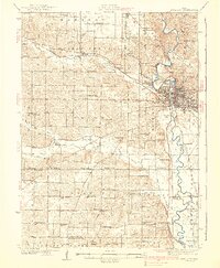
1938 Map of Iowa City
USGS Topo · Published 1938About this map
Iowa City and its surrounding townships appear in a period of agricultural stability and institutional growth along the banks of the Iowa River. The map meticulously records the rural school system of the 1930s, documenting dozens of named institutions like Sandhill Sch and Hartsock Sch that served the dispersed farming community. The presence of the State Sanatorium near Oakdale and the School No 1 County Farm reflects the era's specialized social and medical infrastructure.
Find a feature on this map
84 named features on this map. Tap any name to fly to it.
Don’t see what you’re looking for? This feature index may not catch every label — zoom into the map to look around manually.
Map Details
Editions of this 1938 Iowa City Map
3 editions found

Other maps of this area

1887 · Cedar Rapids
USGS Topo · 1:62,500

1888 · Amana
USGS Topo · 1:62,500

1889 · Amana
USGS Topo · 1:62,500

1891 · Oxford
USGS Topo · 1:62,500

1891 · Mechanicsville
USGS Topo · 1:62,500

1891 · Cedar Rapids
USGS Topo · 1:62,500

1891 · Iowa City
USGS Topo · 1:62,500

1894 · Mechanicsville
USGS Topo · 1:62,500

1894 · Oxford
USGS Topo · 1:62,500

1894 · West Liberty
USGS Topo · 1:62,500