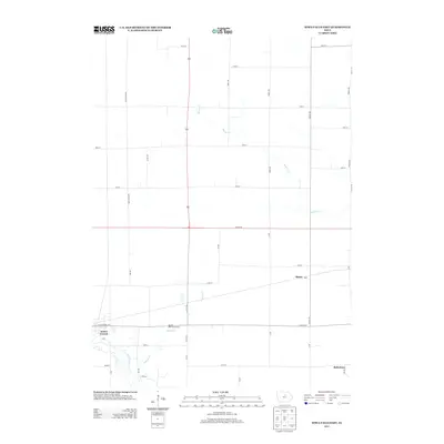
2013 Map of Iowa Falls East
USGS Topo · Published 2013About this map
Iowa Falls occupies the southwestern corner of this quadrangle, where the Iowa River meanders through the landscape. The river is joined by School Creek, which flows south past the Meadow Hills Golf Course. This portion of Hardin County exhibits a transition from the structured urban streets of the city to a vast grid of rural roads, including Hardin Rd and several numbered thoroughfares like 110th St. To the east, the small settlements of Macey and Robertson are situated along the rail lines and local connectors, reflecting the area's agricultural and transportation roots. The northern and central sections are dominated by the winding course of Beaver Creek, which cuts through the agricultural sections defined by long north-south avenues such as Raven Ave and Quail Ave.
Find a feature on this map
39 named features on this map. Tap any name to fly to it.
Don’t see what you’re looking for? This feature index may not catch every label — zoom into the map to look around manually.
Map Details
Editions of this 2013 Iowa Falls East Map
This is the sole edition of this map. No revisions or reprints were ever made.
Other maps of this area

1954 · Waterloo
USGS Topo · 1:250,000

1955 · Waterloo
USGS Topo · 1:250,000

1979 · Ackley NE
USGS Topo · 1:24,000

1979 · Coulter
USGS Topo · 1:24,000

1979 · Iowa Falls West
USGS Topo · 1:24,000

1979 · Buckeye East
USGS Topo · 1:24,000

1979 · Ackley
USGS Topo · 1:24,000

1979 · Steamboat Rock
USGS Topo · 1:24,000

1979 · Iowa Falls East
USGS Topo · 1:24,000
1979 · Hampton South
USGS Topo · 1:24,000