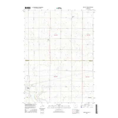
2015 Map of Iowa Falls East
USGS Topo · Published 2015About this map
Iowa Falls serves as the focal point for this survey of the north-central Iowa agricultural landscape, situated along the southern bend of the Iowa River. The map illustrates the structured township and range system that defines the region, specifically marking the intersection of Franklin and Hardin Counties along Hardin Rd. The area is characterized by a high density of small rural burial grounds, including the Saint Peters Evangelical Cem and Pleasant Hill Cem, which offer significant data points for genealogical research in this part of the state. Watercourses like Beaver Cr and School Cr cut through the gridded road network of avenues and streets, leading toward the small settlement of Robertson in the southeast. This layout reflects the long-standing agricultural property divisions and the importance of localized community landmarks in the modern rural Midwest.
Find a feature on this map
47 named features on this map. Tap any name to fly to it.
Don’t see what you’re looking for? This feature index may not catch every label — zoom into the map to look around manually.
Map Details
Editions of this 2015 Iowa Falls East Map
This is the sole edition of this map. No revisions or reprints were ever made.
Other maps of this area

1954 · Waterloo
USGS Topo · 1:250,000

1955 · Waterloo
USGS Topo · 1:250,000

1979 · Ackley NE
USGS Topo · 1:24,000

1979 · Coulter
USGS Topo · 1:24,000

1979 · Iowa Falls West
USGS Topo · 1:24,000

1979 · Buckeye East
USGS Topo · 1:24,000

1979 · Ackley
USGS Topo · 1:24,000

1979 · Steamboat Rock
USGS Topo · 1:24,000

1979 · Iowa Falls East
USGS Topo · 1:24,000
1979 · Hampton South
USGS Topo · 1:24,000