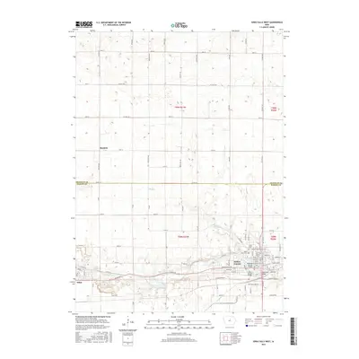
2015 Map of Iowa Falls West
USGS Topo · Published 2015About this map
The Iowa River flows through the southern half of this landscape, anchoring the developed corridors of Iowa Falls and Alden. In the city of Iowa Falls, the map details the campus of Ellsworth Community Coll and the street grid south of Elk Run. These settlements are linked by a network of county roads including Co Rd D15 and Co Rd D20, reflecting the region's long-standing agricultural and transport patterns. North of the river, the terrain transitions into the grid-patterned farmland of t90n r21w, where the small settlement of Burdette sits along 30th St. Local history is preserved in sites like Union Cem and Saint Marks Cem, which serve as vital landmarks for genealogical research. The juxtaposition of established residential areas against the newer Industrial Park Rd illustrates the evolving economic footprint along the river valley.
Find a feature on this map
51 named features on this map. Tap any name to fly to it.
Don’t see what you’re looking for? This feature index may not catch every label — zoom into the map to look around manually.
Map Details
Editions of this 2015 Iowa Falls West Map
This is the sole edition of this map. No revisions or reprints were ever made.
Other maps of this area

1954 · Waterloo
USGS Topo · 1:250,000

1955 · Waterloo
USGS Topo · 1:250,000

1979 · Dows East
USGS Topo · 1:24,000

1979 · Coulter
USGS Topo · 1:24,000

1979 · Iowa Falls West
USGS Topo · 1:24,000

1979 · Buckeye West
USGS Topo · 1:24,000

1979 · Buckeye East
USGS Topo · 1:24,000

1979 · Popejoy
USGS Topo · 1:24,000

1979 · Iowa Falls East
USGS Topo · 1:24,000
1979 · Hampton South
USGS Topo · 1:24,000