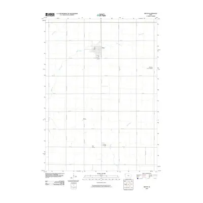
2010 Map of Ireton
USGS Topo · Published 2010About this map
Ireton serves as the primary hub for this agricultural landscape in northwestern Iowa, its grid-like streets centered around the Ireton Post Office. The surrounding Sioux County countryside is defined by a dense network of sectional roads and the meandering courses of Indian Creek and Spring Creek. For those tracing local history, the distribution of burial sites like Pleasant Hill Cemetery, Saint Pauls Lutheran Cemetery, and the Dunkard Cemetery suggests the strong presence of established faith communities in the rural sections. To the south, the smaller settlement of Craig sits near the headwaters of Mink Creek, marking another vital point of rural social organization. The map illustrates a mature farming region where the geometry of modern land management follows the contours of several vital prairie waterways.
Find a feature on this map
32 named features on this map. Tap any name to fly to it.
Don’t see what you’re looking for? This feature index may not catch every label — zoom into the map to look around manually.
Map Details
Editions of this 2010 Ireton Map
This is the sole edition of this map. No revisions or reprints were ever made.
Other maps of this area

1955 · Sioux City
USGS Topo · 1:250,000

1955 · Sioux Falls
USGS Topo · 1:250,000

1958 · Sioux City
USGS Topo · 1:250,000

1958 · Sioux Falls
USGS Topo · 1:250,000

1959 · Sioux City
USGS Topo · 1:250,000

1962 · Le Mars
USGS Topo · 1:62,500

1964 · Sioux Center
USGS Topo · 1:24,000
1968 · Hawarden North
USGS Topo · 1:24,000

1968 · Labanon
USGS Topo · 1:24,000
1969 · Ireton
USGS Topo · 1:24,000