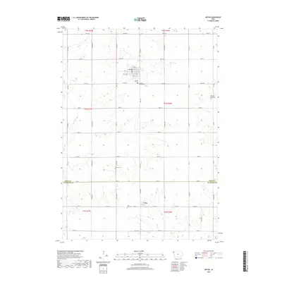
2018 Map of Ireton
USGS Topo · Published 2018About this map
Ireton sits at the heart of this agricultural landscape in Sioux County, where a rigid grid of section roads meets the winding courses of Indian Cr and Spring Cr. The settlement pattern is defined by small rural hubs and the legacies of early congregations, as seen in the clustered cemeteries surrounding the town, including Pleasant Hill Cem and Saint Pauls Lutheran Cem. To the south, across the border in Plymouth County, the village of Craig anchors the lower portion of the map. The drainage of Mink Cr carves subtle relief into the prairie, illustrating the natural watercourses that originally guided the development of these farmstead-rich townships. For genealogists, the map is a primary reference for locating specific burial grounds like the Dunkard Cem and the Saint Johns Evangelical Lutheran Cem, which remain as distinct landmarks of the area's pioneer heritage.
Find a feature on this map
39 named features on this map. Tap any name to fly to it.
Don’t see what you’re looking for? This feature index may not catch every label — zoom into the map to look around manually.
Map Details
Editions of this 2018 Ireton Map
This is the sole edition of this map. No revisions or reprints were ever made.
Other maps of this area

1955 · Sioux City
USGS Topo · 1:250,000

1955 · Sioux Falls
USGS Topo · 1:250,000

1958 · Sioux City
USGS Topo · 1:250,000

1958 · Sioux Falls
USGS Topo · 1:250,000

1959 · Sioux City
USGS Topo · 1:250,000

1962 · Le Mars
USGS Topo · 1:62,500

1964 · Sioux Center
USGS Topo · 1:24,000
1968 · Hawarden North
USGS Topo · 1:24,000

1968 · Labanon
USGS Topo · 1:24,000
1969 · Ireton
USGS Topo · 1:24,000