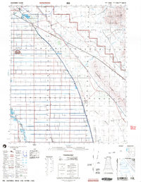
2002 Map of Iris
USGS Topo · Published 2004About this map
The Algodones Dunes dominate the eastern landscape of this Imperial County region, marking a stark contrast between the desert sands and the intensive irrigation of the western basin. Water management is the primary driver of development here, centered on the Coachella Canal and the Alamo River. These systems support a network of agricultural infrastructure, including a filtration plant, Flowing Wells, and numerous feedlots.
Find a feature on this map
29 named features on this map. Tap any name to fly to it.
Don’t see what you’re looking for? This feature index may not catch every label — zoom into the map to look around manually.
Map Details
Editions of this 2002 Iris Map
This is the sole edition of this map. No revisions or reprints were ever made.
Other maps of this area

1907 · Holtville
USGS Topo · 1:125,000

1915 · El Centro
USGS Topo · 1:125,000

1940 · Brawley
USGS Topo · 1:62,500

1940 · Iris
USGS Topo · 1:62,500

1940 · Frink
USGS Topo · 1:62,500

1940 · Iris Pass
USGS Topo · 1:62,500

1940 · Alamorio
USGS Topo · 1:62,500

1942 · El Centro
USGS Topo · 1:250,000

1943 · Brawley
USGS Topo · 1:62,500

1944 · Calipatria
USGS Topo · 1:62,500