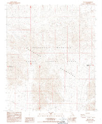
1987 Map of Iris Pass
USGS Topo · Published 1987About this map
The Chocolate Mountains dominate this 1980s landscape, an area characterized by its integration into the Chocolate Mountain Aerial Gunnery Range. This mid-century military training ground spans the border between Riverside and Imperial Counties, where restricted access and military utility define the land use. Drainage through the arid terrain is marked by seasonal watercourses like Iris Wash, which cuts through the high-elevation basins. The map provides a look at the transition from rugged mountain peaks to the broad washes used for aerial maneuvers, recording the specialized infrastructure of a Cold War-era desert range before modern technological shifts in military surveying.
Find a feature on this map
6 named features on this map. Tap any name to fly to it.
Don’t see what you’re looking for? This feature index may not catch every label — zoom into the map to look around manually.
Map Details
Editions of this 1987 Iris Pass Map
2 editions found
Other maps of this area

1940 · Frink
USGS Topo · 1:62,500

1940 · Iris Pass
USGS Topo · 1:62,500

1940 · Canyon Spring
USGS Topo · 1:62,500

1943 · Canyon Spring
USGS Topo · 1:62,500

1944 · Chuckwalla Mountains
USGS Topo · 1:62,500

1944 · Frink
USGS Topo · 1:62,500

1945 · Iris Pass
USGS Topo · 1:62,500

1954 · Salton Sea
USGS Topo · 1:250,000

1955 · Salton Sea
USGS Topo · 1:250,000
1956 · Wister
USGS Topo · 1:24,000