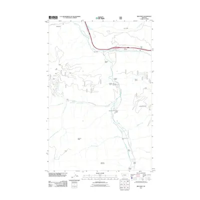
2011 Map of Iris Point
USGS Topo · Published 2011About this map
The Clark Fork river and the canyon of Rock Creek dominate this landscape southeast of Missoula in the early 21st century. The map centers on the small community of Iris and the nearby Rock Creek Lodge, a long-standing gateway for anglers and travelers. Infrastructure including Old US Hwy 10 and the Elliot Airstrip follow the valley floor, while numerous gulches such as Moe Gulch and Rickard Gulch cut into the surrounding highlands.
Find a feature on this map
39 named features on this map. Tap any name to fly to it.
Don’t see what you’re looking for? This feature index may not catch every label — zoom into the map to look around manually.
Map Details
Editions of this 2011 Iris Point Map
This is the sole edition of this map. No revisions or reprints were ever made.
Other maps of this area

1903 · Bonner
USGS Topo · 1:125,000

1947 · Butte
USGS Topo · 1:250,000

1958 · Butte
USGS Topo · 1:250,000

1959 · Cleveland Mountain
USGS Topo · 1:62,500

1959 · Ravenna
USGS Topo · 1:62,500

1960 · Butte
USGS Topo · 1:250,000

1962 · Butte
USGS Topo · 1:250,000
1965 · Clinton
USGS Topo · 1:24,000
1965 · Mineral Ridge
USGS Topo · 1:24,000
1965 · Bonner
USGS Topo · 1:24,000