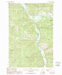
1989 Map of Iris Point
USGS Topo · Published 1989About this map
Clark Fork and Rock Creek converge in this western Montana landscape, dominated by the dense drainage networks of the Lolo National Forest. The 1980s terrain is characterized by steep ridges and narrow gulches, such as Rickard Gulch and Fiddler Gulch, that feed into the primary river systems. Human activity is concentrated along the river corridors, where transportation routes and federal land management infrastructure are established. The map highlights the Welcome Creek Wilderness to the south, a protected area bounded by Solomon Ridge and Solomon Mountain. Evidence of regional aviation and forest management is visible through features like the Elliott Airstrip and the Bonita FS Station, while a Borrow Pit and Gravel Pit near the highway indicate the ongoing maintenance of this mountain corridor.
Find a feature on this map
36 named features on this map. Tap any name to fly to it.
Don’t see what you’re looking for? This feature index may not catch every label — zoom into the map to look around manually.
Map Details
Editions of this 1989 Iris Point Map
This is the sole edition of this map. No revisions or reprints were ever made.
Other maps of this area

1903 · Bonner
USGS Topo · 1:125,000

1947 · Butte
USGS Topo · 1:250,000

1958 · Butte
USGS Topo · 1:250,000

1959 · Cleveland Mountain
USGS Topo · 1:62,500

1959 · Ravenna
USGS Topo · 1:62,500

1960 · Butte
USGS Topo · 1:250,000

1962 · Butte
USGS Topo · 1:250,000
1965 · Clinton
USGS Topo · 1:24,000
1965 · Mineral Ridge
USGS Topo · 1:24,000
1965 · Bonner
USGS Topo · 1:24,000