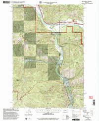
1999 Map of Iris Point
USGS Topo · Published 2003About this map
Clark Fork and Rock Creek define the geography of this rugged corridor along the boundary of Missoula and Granite counties. In the late twentieth century, the area served as a gateway to the high country of the Lolo National Forest, featuring small-scale aviation at Elliott Airstrip and specialized service points like the Rock Creek Lodge. The drainage patterns of Swartz Creek and Starvation Creek descend into the main valley, while the southern reaches of the map transition into the protected landscape of the Welcome Creek Wilderness. Local landmarks like Phelan Ranch and the Bonita FS Workcenter provide glimpses into the ranching and forestry operations that shaped the region's human history. Notable elevations including Iris Point and Babcock Mountain tower over the Valley of the Moon Fishing Access, highlighting the area's long-standing importance for outdoor recreation and public land management.
Find a feature on this map
33 named features on this map. Tap any name to fly to it.
Don’t see what you’re looking for? This feature index may not catch every label — zoom into the map to look around manually.
Map Details
Editions of this 1999 Iris Point Map
This is the sole edition of this map. No revisions or reprints were ever made.
Other maps of this area

1903 · Bonner
USGS Topo · 1:125,000

1947 · Butte
USGS Topo · 1:250,000

1958 · Butte
USGS Topo · 1:250,000

1959 · Cleveland Mountain
USGS Topo · 1:62,500

1959 · Ravenna
USGS Topo · 1:62,500

1960 · Butte
USGS Topo · 1:250,000

1962 · Butte
USGS Topo · 1:250,000
1965 · Clinton
USGS Topo · 1:24,000
1965 · Mineral Ridge
USGS Topo · 1:24,000
1965 · Bonner
USGS Topo · 1:24,000