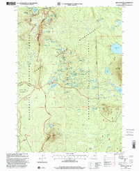
1997 Map of Irish Mountain
USGS Topo · Published 2001About this map
The high alpine landscape of the Cascade Range is meticulously documented in this late-1990s revision, defined by the high boundary between Lane Co and Deschutes Co. This territory is dominated by protected lands, including portions of the Three Sisters Wilderness and the Waldo Lake Wilderness. A remarkable concentration of high-elevation water bodies like McFarland Lake, Irish Lake, and the aptly named Stormy Lake dot the volcanic terrain. The Pacific Crest National Scenic Trail traverses the western slope of Irish Mountain, providing a critical transit corridor through the Deschutes National Forest. Further south, landmarks such as Charlton Butte and Clover Meadow offer points of interest for those studying the backcountry access points and recreational history of the region, including the established Harralson Horse Camp.
Find a feature on this map
68 named features on this map. Tap any name to fly to it.
Don’t see what you’re looking for? This feature index may not catch every label — zoom into the map to look around manually.
Map Details
Editions of this 1997 Irish Mountain Map
This is the sole edition of this map. No revisions or reprints were ever made.
Other maps of this area

1925 · Waldo Lake
USGS Topo · 1:125,000

1930 · Maiden Peak
USGS Topo · 1:125,000

1934 · Maiden Peak
USGS Topo · 1:125,000

1955 · Chucksney Mtn
USGS Topo · 1:62,500

1955 · Crescent
USGS Topo · 1:250,000

1956 · Waldo Lake
USGS Topo · 1:62,500

1957 · Crescent
USGS Topo · 1:250,000

1958 · Crescent
USGS Topo · 1:250,000

1958 · Roseburg
USGS Topo · 1:250,000

1959 · Roseburg
USGS Topo · 1:250,000