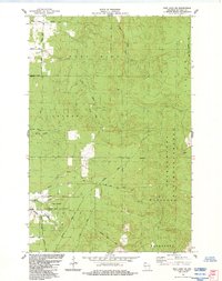
1984 Map of Iron Lake NE
USGS Topo · Published 1984About this map
The National Fish Hatchery sits at the confluence of several waterways in the southern portion of this region, emphasizing the importance of the local watershed to 1980s conservation efforts. Much of the terrain is defined by the Chequamegon National Forest, where the landscape is etched with the remnants of industrial history. An Old Railroad Grade winds through the central township, marking a previous era of timber transport that once dominated the northern woods. Numerous family-named roads, such as Larson Road, Mc Lean Road, and Hessey Road, cross the land, providing a record of local land ownership and rural settlement patterns. The drainage network is particularly dense here, featuring the Iron River, Kolin Creek, and the headwaters of the Flag River, while secluded water bodies like Pine Lake and Bladder Lake anchor the interior forest.
Find a feature on this map
37 named features on this map. Tap any name to fly to it.
Don’t see what you’re looking for? This feature index may not catch every label — zoom into the map to look around manually.
Map Details
Editions of this 1984 Iron Lake NE Map
This is the sole edition of this map. No revisions or reprints were ever made.
Other maps of this area

1943 · Port Wing
USGS Topo · 1:48,000

1943 · Iron Lake
USGS Topo · 1:48,000

1944 · Moquah
USGS Topo · 1:48,000

1944 · Cornucopia
USGS Topo · 1:48,000

1946 · Cornucopia
USGS Topo · 1:48,000

1946 · Port Wing
USGS Topo · 1:48,000

1947 · Moquah
USGS Topo · 1:48,000

1947 · Iron Lake
USGS Topo · 1:48,000

1953 · Ashland
USGS Topo · 1:250,000

1958 · Ashland
USGS Topo · 1:250,000