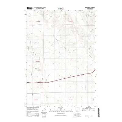
2015 Map of Iron Mountain
USGS Topo · Published 2015About this map
Pine Ridge dominates the central landscape of this Crook County terrain, where high divides and narrow drainages define the ranching and timbered character of northeastern Wyoming. The historic route of the Deadwood Stage Rd traverses the western portion of the map, a remnant of the region's 19th-century gold rush and pioneer travel networks. The area around Iron Mtn is marked by a complex system of local tracks including Old Sundance Rd, Happy Cabin Rd, and Tom Cat Ln, which connect isolated homesteads and water sources like Sommers Reservoir. These names reflect the local heritage of the frontier era, while the convergence of Inyan Kara Cr and Tomcat Cr illustrates the reliance on intermittent drainages in the high plains. The map captures the continued significance of high-elevation features like the Nefsy Divide and Little Pine Ridge in shaping the modern road and property networks.
Find a feature on this map
40 named features on this map. Tap any name to fly to it.
Don’t see what you’re looking for? This feature index may not catch every label — zoom into the map to look around manually.
Map Details
Editions of this 2015 Iron Mountain Map
This is the sole edition of this map. No revisions or reprints were ever made.
Other maps of this area
1918 · Moorcroft
USGS Topo · 1:125,000
1918 · Moorcroft
USGS Topo · 1:62,500
1954 · Sunny Divide
USGS Topo · 1:24,000
1954 · Carlile
USGS Topo · 1:24,000

1954 · Gillette
USGS Topo · 1:250,000

1955 · Gillette
USGS Topo · 1:250,000
1957 · Nefsy Divide
USGS Topo · 1:62,500
1957 · Moorcroft
USGS Topo · 1:62,500
1957 · Upton
USGS Topo · 1:62,500

1958 · Gillette
USGS Topo · 1:250,000