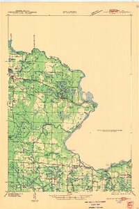
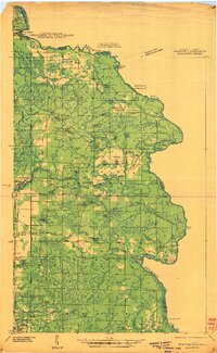
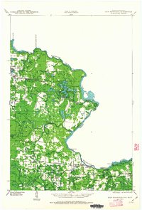
1947 Map of Iron Mountain
USGS Topo · Published 1947About this map
The Menominee River carves a jagged border between Wisconsin and Michigan in this mid-century survey, defining a landscape shaped by hydroelectric power and the timber-to-mining transition. Industrial nodes are centered on the river's descent, notably at Big Quinnesec Falls and the Henry Ford Dam, while the Chicago and Northwestern Railroad cuts through the northern timberlands to serve settlements like Commonwealth and Hematite. The southern portion of the map reveals a dense network of rural infrastructure, where local life revolved around numerous small district schools such as Golden Rule Sch, Fairview Sch, and Mountain Sch. The map also captures a recreational layer around the glacial lake clusters, including Spreadeagle Lake and Lake Anna, alongside early roadside developments like Vagabond Cabins.
Find a feature on this map
55 named features on this map. Tap any name to fly to it.
Don’t see what you’re looking for? This feature index may not catch every label — zoom into the map to look around manually.
Map Details
Editions of this 1947 Iron Mountain Map
This is the sole edition of this map. No revisions or reprints were ever made.
Other maps of this area

1899 · Sagola
USGS Topo · 1:62,500

1899 · Crystal Falls
USGS Topo · 1:62,500
1939 · Pembine
USGS Topo · 1:48,000
1939 · Dunbar
USGS Topo · 1:48,000
1939 · Goodman
USGS Topo · 1:48,000
1939 · Iron Mountain
USGS Topo · 1:48,000

1941 · Florence
USGS Topo · 1:48,000
1941 · Dunbar
USGS Topo · 1:48,000

1941 · Iron Mountain
USGS Topo · 1:48,000
1944 · Crystal Falls
USGS Topo · 1:24,000