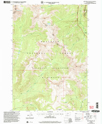
2000 Map of Iron Mountain
USGS Topo · Published 2005About this map
Gallatin National Forest and the Absaroka Beartooth Wilderness dominate this high-altitude landscape in Park County, where the hydrological divide of Middle Ridge separates complex drainage systems. The topography is defined by the steep ascent toward Iron Mountain and the secluded Hummingbird Basin, while the eastern boundary is carved by the Boulder River and its South Fork Boulder River.
Find a feature on this map
26 named features on this map. Tap any name to fly to it.
Don’t see what you’re looking for? This feature index may not catch every label — zoom into the map to look around manually.
Map Details
Editions of this 2000 Iron Mountain Map
This is the sole edition of this map. No revisions or reprints were ever made.
Other maps of this area

1891 · Livingston
USGS Topo · 1:250,000

1893 · Livingston
USGS Topo · 1:250,000

1940 · Mt. Cowen
USGS Topo · 1:62,500

1940 · Mt Wallace
USGS Topo · 1:62,500

1941 · Mt Douglas
USGS Topo · 1:62,500

1942 · Cutoff Mtn
USGS Topo · 1:62,500

1943 · Mt Wallace
USGS Topo · 1:62,500

1943 · Mt Douglas
USGS Topo · 1:62,500

1943 · Mt Cowen
USGS Topo · 1:62,500

1944 · Cutoff Mtn
USGS Topo · 1:62,500