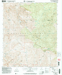
2004 Map of Iron Mountain
USGS Topo · Published 2007About this map
Iron Mountain dominates the center of this remote desert landscape within the Superstition Wilderness, a high-elevation portion of the Tonto National Forest. The map details a transition from the drainage of Fish Creek in the north to the headwaters of Pinto Creek and Tortilla Creek in the south, punctuated by isolated ranching and mining sites. Evidence of early cattle operations appears at J F Headquarters and the Corral near Woodbury, while the presence of prospects in Hackberry Canyon and near Mound Mountain hints at the region's mineral exploration history. Historical travel through these basins is traced via the Reavis Trail, which connects remote water sources like Honeycutt Spring and Reavis Saddle Spring. These springs and seasonal seeps were critical waypoints in a landscape defined by names like Angel Basin and Rough Canyon.
Find a feature on this map
79 named features on this map. Tap any name to fly to it.
Don’t see what you’re looking for? This feature index may not catch every label — zoom into the map to look around manually.
Map Details
Editions of this 2004 Iron Mountain Map
This is the sole edition of this map. No revisions or reprints were ever made.
Other maps of this area

1900 · Florence
USGS Topo · 1:125,000

1902 · Florence
USGS Topo · 1:125,000

1907 · Roosevelt
USGS Topo · 1:125,000

1909 · Four Peaks
USGS Topo · 1:125,000

1912 · Roosevelt
USGS Topo · 1:125,000

1948 · Superior
USGS Topo · 1:62,500

1948 · Superior
USGS Topo · 1:24,000

1948 · Iron Mountain
USGS Topo · 1:24,000
1948 · Haunted Canyon
USGS Topo · 1:24,000

1948 · Picketpost Mtn
USGS Topo · 1:24,000