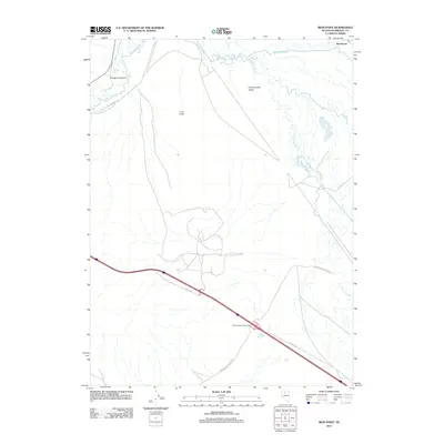
2011 Map of Iron Point
USGS Topo · Published 2011About this map
The Humboldt River meanders across the northern portion of this Nevada landscape, accompanied by the slow waters of Herrin Slough as it winds through the Pumpernickel Valley. This area preserves a layered history of western transit, where the modern interstate corridor parallels the historic Old Emigrant Trl. Near Emigrant Canyon, the terrain shifts from open valley to more confined geographic features that once challenged overland travelers. Small settlements and named locales like Iron Point and Red House anchor the map, serving as critical points of reference in a territory defined by its drainage patterns and vast alluvial stretches. The infrastructure of the early 21st century is represented by the Pumpernickel Interchange, illustrating how modern logistics have mapped themselves onto the same essential routes followed by pioneers over a century prior.
Find a feature on this map
11 named features on this map. Tap any name to fly to it.
Don’t see what you’re looking for? This feature index may not catch every label — zoom into the map to look around manually.
Map Details
Editions of this 2011 Iron Point Map
This is the sole edition of this map. No revisions or reprints were ever made.
Other maps of this area

1882 · Paradise
USGS Topo · 1:250,000

1893 · Paradise
USGS Topo · 1:250,000

1932 · Sonoma Range
USGS Topo · 1:250,000

1939 · Sonoma Range
USGS Topo · 1:250,000

1945 · Osgood Mountains
USGS Topo · 1:62,500

1947 · Osgood Mountains
USGS Topo · 1:62,500

1955 · McDermitt
USGS Topo · 1:250,000

1955 · Winnemucca
USGS Topo · 1:250,000

1958 · Winnemucca
USGS Topo · 1:250,000

1959 · McDermitt
USGS Topo · 1:250,000