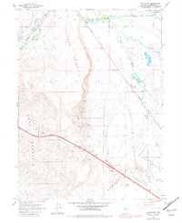
1965 Map of Iron Point
USGS Topo · Published 1981About this map
Humboldt River meanders through the northern reaches of this Great Basin landscape, following a corridor shared by the Western Pacific and Southern Pacific railroads. The area represents a critical historical transit point where the Emigrant Trail (Old) aligns with modern infrastructure between Edna Mountain and the Iron Point ridges. Mining activity is concentrated along the western slopes, evidenced by the Silver King Mine and Silver Coin Mine, while the southern portion of the quadrangle opens into the broad Pumpernickel Valley. Small settlements like Iron Point and Red House mark the rail line, providing glimpses into the sparse but strategic development of Humboldt County during the mid-20th century. The presence of a Gaging Station and various Herrin Sloughs highlights the importance of water management in this arid Nevada terrain.
Find a feature on this map
23 named features on this map. Tap any name to fly to it.
Don’t see what you’re looking for? This feature index may not catch every label — zoom into the map to look around manually.
Map Details
Editions of this 1965 Iron Point Map
3 editions found
Other maps of this area

1882 · Paradise
USGS Topo · 1:250,000

1893 · Paradise
USGS Topo · 1:250,000

1932 · Sonoma Range
USGS Topo · 1:250,000

1939 · Sonoma Range
USGS Topo · 1:250,000

1945 · Osgood Mountains
USGS Topo · 1:62,500

1947 · Osgood Mountains
USGS Topo · 1:62,500

1955 · McDermitt
USGS Topo · 1:250,000

1955 · Winnemucca
USGS Topo · 1:250,000

1958 · Winnemucca
USGS Topo · 1:250,000

1959 · McDermitt
USGS Topo · 1:250,000