
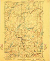
1898 Map of Iron River
USGS Topo · Published 1899About this map
The early iron-mining landscapes of the Upper Peninsula take shape in this late 19th-century survey. The settlements of Iron River and Stambaugh sit at the center of a developing transport network, where the Chicago and Northwestern R. R. extends its tracks to reach timber and ore. This era was defined by the rapid expansion of these industrial corridors, notably the Atkinson Branch leading northwest to Atkinson. Beyond the developing towns, the terrain is defined by a dense network of glacial water bodies, including the large Chicagon Lake in the southeast and Iron Lake near the center. The Paint River and Brule River serve as natural markers, the latter tracing the Michigan-Wisconsin boundary. This documentation by Robert Muldrow captures the transition from wilderness to an extraction-based economy, noting small outposts like Hazle and Saunders before the height of 20th-century development.
Find a feature on this map
31 named features on this map. Tap any name to fly to it.
Don’t see what you’re looking for? This feature index may not catch every label — zoom into the map to look around manually.
Map Details
Editions of this 1898 Iron River Map
2 editions found
Other maps of this area

1895 · Ned Lake
USGS Topo · 1:62,500

1895 · Perch Lake
USGS Topo · 1:62,500

1899 · Crystal Falls
USGS Topo · 1:62,500

1938 · Alvin
USGS Topo · 1:48,000

1939 · Long Lake
USGS Topo · 1:48,000

1941 · Florence
USGS Topo · 1:48,000

1944 · Iron River
USGS Topo · 1:24,000

1944 · Gaastra
USGS Topo · 1:24,000

1944 · Fortune Lakes
USGS Topo · 1:24,000

1945 · Gibbs City
USGS Topo · 1:24,000