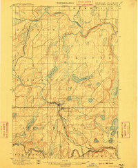
1898 Map of Iron River
USGS Topo · Published 1910About this map
The Chicago and North Western R. R. dictates the rhythm of this Upper Peninsula landscape, connecting the clustered settlements of Iron River and Stambaugh to the wider region during a period of heavy industrial growth. This survey captures the terrain as it transitioned into a mining and logging hub, with small outposts like Atkinson and Hazle positioned along the rail lines and watercourses. To the south, the Brule River marks the Michigan Wisconsin border, winding through a glacial topography characterized by numerous large water bodies such as Chicagon Lake and Stanley Lake. The map reveals the intricate network of the Paint River and Net River in the north, which served as vital corridors for the timber industry before the road networks were fully established.
Find a feature on this map
29 named features on this map. Tap any name to fly to it.
Don’t see what you’re looking for? This feature index may not catch every label — zoom into the map to look around manually.
Map Details
Editions of this 1898 Iron River Map
2 editions found
Other maps of this area

1895 · Ned Lake
USGS Topo · 1:62,500

1895 · Perch Lake
USGS Topo · 1:62,500

1898 · Iron River
USGS Topo · 1:62,500

1899 · Crystal Falls
USGS Topo · 1:62,500

1938 · Alvin
USGS Topo · 1:48,000

1939 · Long Lake
USGS Topo · 1:48,000

1941 · Florence
USGS Topo · 1:48,000

1944 · Iron River
USGS Topo · 1:24,000

1944 · Gaastra
USGS Topo · 1:24,000

1944 · Fortune Lakes
USGS Topo · 1:24,000