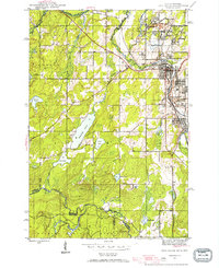
1944 Map of Iron River
USGS Topo · Published 1956About this map
Mining operations dominate the landscape of this 1944 survey, revealing the dense industrial activity surrounding the communities of Iron River, Stambaugh, and Caspian. The concentration of iron ore extraction is evident through a series of named shafts and locations, including the Forbes Mine, Homer Mine, and James Mine, which are interconnected by the Chicago and Northwestern rail lines. Beyond the urban centers of Mineral Hills and Virgil Location, the map transitions into the deep timber of the Ottawa National Forest, straddling the border between Michigan and Wisconsin. Notable natural features like Stanley Lake and the meandering Iron River provide a stark contrast to the nearby industrial landscape. Local governance is represented by the Township Hall, while early settlements like Forbes Location reflect the worker-oriented geography of the Upper Peninsula at mid-century.
Find a feature on this map
42 named features on this map. Tap any name to fly to it.
Don’t see what you’re looking for? This feature index may not catch every label — zoom into the map to look around manually.
Map Details
Editions of this 1944 Iron River Map
2 editions found
Other maps of this area

1898 · Iron River
USGS Topo · 1:62,500

1938 · Alvin
USGS Topo · 1:48,000

1939 · Long Lake
USGS Topo · 1:48,000

1944 · Iron River
USGS Topo · 1:24,000

1944 · Gaastra
USGS Topo · 1:24,000

1945 · Gibbs City
USGS Topo · 1:24,000

1945 · Sunset Lake
USGS Topo · 1:24,000

1946 · Iron River
USGS Topo · 1:31,680

1946 · Sunset Lake
USGS Topo · 1:31,680

1946 · Gaastra
USGS Topo · 1:31,680