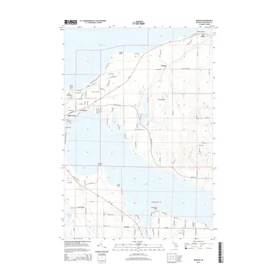
2014 Map of Ironton
USGS Topo · Published 2014About this map
Lake Charlevoix and the surrounding shoreline are the dominant features of this coastal Michigan landscape, where the settlement of Ironton sits along the southern narrows. To the north, the city of Charlevoix spans the channel between the inland lake and Lake Michigan, with landmarks like Mt McSauba and Park Island punctuating the lakefront. The interior reveals a complex system of smaller water bodies and drainages, including Susan Lake, Mud Lake, and the winding path of Susan Cr.
Find a feature on this map
116 named features on this map. Tap any name to fly to it.
Don’t see what you’re looking for? This feature index may not catch every label — zoom into the map to look around manually.
Map Details
Editions of this 2014 Ironton Map
This is the sole edition of this map. No revisions or reprints were ever made.
Other maps of this area

1954 · Central Lake
USGS Topo · 1:62,500

1954 · Charlevoix
USGS Topo · 1:62,500

1955 · Cheboygan
USGS Topo · 1:250,000

1958 · Cheboygan
USGS Topo · 1:250,000

1958 · Bayshore
USGS Topo · 1:62,500

1961 · Boyne City
USGS Topo · 1:62,500

1975 · Boyne City NW
USGS Topo · 1:24,000

1975 · Boyne City NE
USGS Topo · 1:24,000
1983 · Ellsworth
USGS Topo · 1:25,000
1983 · Forest Beach
USGS Topo · 1:25,000