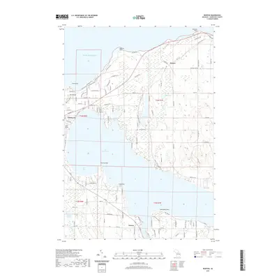
2019 Map of Ironton
USGS Topo · Published 2019About this map
The waters of Lake Michigan and Lake Charlevoix dominate this coastal landscape in Charlevoix County, defining the region's geography through a series of significant peninsulas and bays. The city of Charlevoix occupies the narrow strip of land between the lakes, while the settlement of Ironton marks the transition into the South Arm of Lake Charlevoix. This 2019 survey documents the intricate shoreline features from Ninemile Point in the north to Hemingway Point in the south, including smaller interior bodies of water like Susan Lake and Adams Lake.
Find a feature on this map
114 named features on this map. Tap any name to fly to it.
Don’t see what you’re looking for? This feature index may not catch every label — zoom into the map to look around manually.
Map Details
Editions of this 2019 Ironton Map
This is the sole edition of this map. No revisions or reprints were ever made.
Other maps of this area

1954 · Central Lake
USGS Topo · 1:62,500

1954 · Charlevoix
USGS Topo · 1:62,500

1955 · Cheboygan
USGS Topo · 1:250,000

1958 · Cheboygan
USGS Topo · 1:250,000

1958 · Bayshore
USGS Topo · 1:62,500

1961 · Boyne City
USGS Topo · 1:62,500

1975 · Boyne City NW
USGS Topo · 1:24,000

1975 · Boyne City NE
USGS Topo · 1:24,000
1983 · Ellsworth
USGS Topo · 1:25,000
1983 · Forest Beach
USGS Topo · 1:25,000