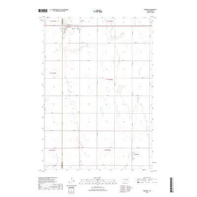
2017 Map of Iroquois
USGS Topo · Published 2017About this map
Iroquois serves as the primary hub in this prairie landscape, situated along the border of Beadle and Kingsbury Counties. The town's grid is anchored by streets such as E Neosho St and S Quapaw St, with several burial grounds clustered nearby, including Maplewood Cem, Saint Paul's Catholic Cem, and the uniquely named Iroquois Cem Mound. These sites provide significant data points for local family history research.
Find a feature on this map
37 named features on this map. Tap any name to fly to it.
Don’t see what you’re looking for? This feature index may not catch every label — zoom into the map to look around manually.
Map Details
Editions of this 2017 Iroquois Map
This is the sole edition of this map. No revisions or reprints were ever made.
Other maps of this area

1899 · De Smet
USGS Topo · 1:125,000

1953 · Watertown
USGS Topo · 1:250,000

1958 · Watertown
USGS Topo · 1:250,000

1971 · Iroquois
USGS Topo · 1:24,000
1971 · Artesian NW
USGS Topo · 1:24,000
1971 · Pearl Creek Colony
USGS Topo · 1:24,000

1971 · Bancroft East
USGS Topo · 1:24,000

1971 · Bancroft West
USGS Topo · 1:24,000
1971 · Yale
USGS Topo · 1:24,000

1971 · Artesian NE
USGS Topo · 1:24,000