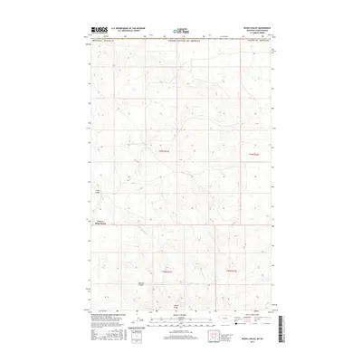
2017 Map of Irvins Coulee
USGS Topo · Published 2017About this map
Cherry Ridge Ranch sits in the open country of Blaine County, Montana, marking a rare point of habitation in this high plains landscape just south of the Canadian border. The drainage of E Fork Battle Cr carves through the terrain, flanked by significant topographical features like Cherry Ridge and the deep recesses of Irvins Coulee. In the southern portion of the map, Bennett Coulee further defines the watershed, illustrating the complex erosional patterns typical of this region's geology. This 2017 survey by the U.S. Geological Survey documents the persistence of large-scale ranching and the network of local roads and watercourses that support it in the northernmost reaches of the state.
Find a feature on this map
12 named features on this map. Tap any name to fly to it.
Don’t see what you’re looking for? This feature index may not catch every label — zoom into the map to look around manually.
Map Details
Editions of this 2017 Irvins Coulee Map
This is the sole edition of this map. No revisions or reprints were ever made.
Other maps of this area

1912 · Zurich
USGS Topo · 1:125,000

1913 · Cherry Ridge
USGS Topo · 1:125,000

1953 · Havre
USGS Topo · 1:250,000

1957 · Havre
USGS Topo · 1:250,000

1958 · Havre
USGS Topo · 1:250,000

1984 · Richmond Reservoir
USGS Topo · 1:24,000
1984 · Silver Bow Lake
USGS Topo · 1:24,000

1984 · Havre
USGS Topo · 1:100,000
1984 · Aubrey Dam
USGS Topo · 1:24,000
1984 · Silver Bow Spring
USGS Topo · 1:24,000