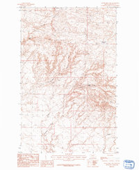
1984 Map of Silver Bow Lake
USGS Topo · Published 1984About this map
West Butte and Middle Butte anchor the high ground of this Montana landscape, where drainage patterns define the sparse high plains environment. The central feature, Silver Bow Lake, sits in a slight depression to the east, while the terrain is deeply etched by seasonal watercourses like Thirtymile Creek and the Northwest Fork Thirtymile Creek. These drainages, including the northern Chouteau Coulee, suggest a landscape shaped by intermittent runoff and erosion. Vital water sources are identified throughout the quadrangle, including Gidley Spring and Laporte Spring, which likely served as critical landmarks for local ranching and transit. Along the northern boundary, Cherry Ridge offers a prominent topographical break, providing a detailed view of the regional hydrology before it reaches Campbell Spring in the southern reaches.
Find a feature on this map
10 named features on this map. Tap any name to fly to it.
Don’t see what you’re looking for? This feature index may not catch every label — zoom into the map to look around manually.
Map Details
Editions of this 1984 Silver Bow Lake Map
This is the sole edition of this map. No revisions or reprints were ever made.
Other maps of this area

1904 · Chinook
USGS Topo · 1:62,500

1905 · Harlem
USGS Topo · 1:62,500

1912 · Zurich
USGS Topo · 1:125,000

1913 · Cherry Ridge
USGS Topo · 1:125,000

1953 · Havre
USGS Topo · 1:250,000

1957 · Havre
USGS Topo · 1:250,000

1958 · Havre
USGS Topo · 1:250,000

1984 · Richmond Reservoir
USGS Topo · 1:24,000
1984 · Harlem NW
USGS Topo · 1:24,000

1984 · Havre
USGS Topo · 1:100,000