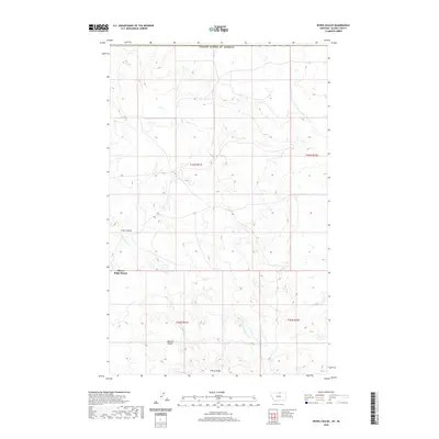
2020 Map of Irvins Coulee
USGS Topo · Published 2020About this map
Cherry Ridge Ranch occupies a central position in this corner of northern Montana, situated among the undulating landforms of the high plains. The landscape is defined by its drainage patterns, specifically the winding course of E Fork Battle Cr and the deep incisions of Irvins Coulee and Bennett Coulee. This map documents a sparsely populated ranching environment where the terrain itself dictates the utility of the land. Cherry Ridge stands as a prominent topographical feature, overseeing the transition between coulees and the broader northern plains. The survey illustrates the intersection of Public Land Survey System townships, including t37n r21e and t36n r21e, providing a precise record of land management and property boundaries in this remote section of Blaine County.
Find a feature on this map
10 named features on this map. Tap any name to fly to it.
Don’t see what you’re looking for? This feature index may not catch every label — zoom into the map to look around manually.
Map Details
Editions of this 2020 Irvins Coulee Map
This is the sole edition of this map. No revisions or reprints were ever made.
Other maps of this area

1912 · Zurich
USGS Topo · 1:125,000

1913 · Cherry Ridge
USGS Topo · 1:125,000

1953 · Havre
USGS Topo · 1:250,000

1957 · Havre
USGS Topo · 1:250,000

1958 · Havre
USGS Topo · 1:250,000

1984 · Richmond Reservoir
USGS Topo · 1:24,000
1984 · Silver Bow Lake
USGS Topo · 1:24,000

1984 · Havre
USGS Topo · 1:100,000
1984 · Aubrey Dam
USGS Topo · 1:24,000
1984 · Silver Bow Spring
USGS Topo · 1:24,000