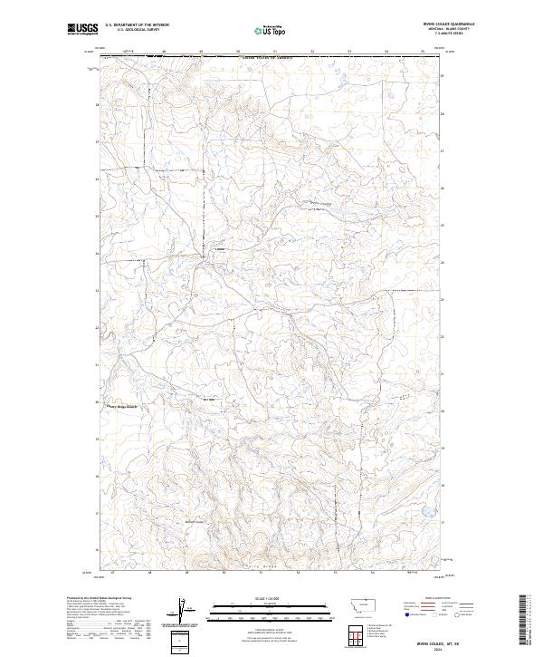
2024 Map of Irvins Coulee
USGS Topo · Published 2024About this map
Cherry Ridge Ranch sits near the heart of this Montana landscape, where the high plains are carved by a complex network of seasonal drainages and topographic landmarks. The map area is defined by the drainage patterns of Irvins Coulee in the north and Bennett Coulee further south, both contributing to the broader watershed. The south-central portion of the quadrangle is dominated by the prominent elevation of Cherry Ridge, while the East Fork Battle Creek meanders through the lower terrain. This land is meticulously organized by the Public Land Survey System, shown through the boundaries of t37n r21e, t37n r22e, and their southern counterparts, which reflect the systematic division of Blaine County for ranching and resource management.
Find a feature on this map
10 named features on this map. Tap any name to fly to it.
Don’t see what you’re looking for? This feature index may not catch every label — zoom into the map to look around manually.
Map Details
Editions of this 2024 Irvins Coulee Map
This is the sole edition of this map. No revisions or reprints were ever made.
Other maps of this area

1912 · Zurich
USGS Topo · 1:125,000

1913 · Cherry Ridge
USGS Topo · 1:125,000

1953 · Havre
USGS Topo · 1:250,000

1957 · Havre
USGS Topo · 1:250,000

1958 · Havre
USGS Topo · 1:250,000

1984 · Richmond Reservoir
USGS Topo · 1:24,000
1984 · Silver Bow Lake
USGS Topo · 1:24,000

1984 · Havre
USGS Topo · 1:100,000
1984 · Aubrey Dam
USGS Topo · 1:24,000
1984 · Silver Bow Spring
USGS Topo · 1:24,000