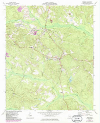
1973 Map of Irwinton
USGS Topo · Published 1986About this map
Irwinton serves as a central hub in this Georgia landscape, situated at a major crossroads south of the Central of Georgia railroad line. The map highlights the agricultural and industrial character of Wilkinson County during the early 1970s, featuring active kaolin mining evidence such as a claypit and several unnamed tailings ponds near McIntyre. The rural geography is defined by a dense network of tributaries including Commissioner Creek and Big Sandy Creek, which carved the undulating terrain that necessitated landmarks like the Wilkinson Lookout Tower.
Find a feature on this map
44 named features on this map. Tap any name to fly to it.
Don’t see what you’re looking for? This feature index may not catch every label — zoom into the map to look around manually.
Map Details
Editions of this 1973 Irwinton Map
2 editions found
Other maps of this area

1916 · Irwinton
USGS Topo · 1:62,500

1920 · Irwinton
USGS Topo · 1:62,500

1956 · Gordon
USGS Topo · 1:62,500

1956 · Jeffersonville
USGS Topo · 1:62,500

1957 · Macon
USGS Topo · 1:250,000

1958 · Macon
USGS Topo · 1:250,000

1964 · Macon
USGS Topo · 1:250,000
1973 · Gordon
USGS Topo · 1:24,000

1973 · Massey Hill
USGS Topo · 1:24,000
1973 · Napier Pond
USGS Topo · 1:24,000