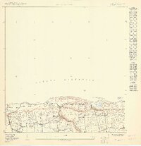
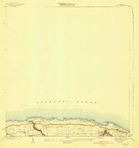
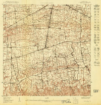
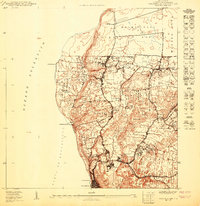
1950 Map of Isabela SO
USGS Topo · Published 1950About this map
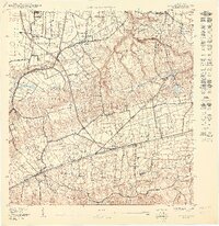
Aguacate and the surrounding barrios of northwest Puerto Rico are documented in this mid-century preliminary survey, showing the agricultural and residential landscape before modern expansion. The coastal topography is defined by prominent natural landmarks like Pta Jacinto and Peña Montones, while the interior reveals the distribution of rural settlements such as San Antonio. The map captures a transition in local infrastructure, noting both religious centers like the Iglesia Católica and Iglesia Presbiteriana alongside industrial or utility sites like Planta No 4. A significant portion of the western territory is designated as a Reservación Militar, bordering the barrio of Maleza Alta. Local water systems are represented by the Quebrada de los Cedros, which winds toward the Océano Atlántico, illustrating the natural drainage patterns of the Montaña and Jobos districts.
Find a feature on this map
18 named features on this map. Tap any name to fly to it.
Don’t see what you’re looking for? This feature index may not catch every label — zoom into the map to look around manually.
Map Details
Editions of this 1950 Isabela SO Map
This is the sole edition of this map. No revisions or reprints were ever made.
Other maps of this area

1937 · Aguadilla
USGS Topo · 1:20,000

1937 · Moca
USGS Topo · 1:20,000

1941 · Moca
USGS Topo · 1:30,000
1941 · Isabela
USGS Topo · 1:30,000

1942 · Moca
USGS Topo · 1:30,000

1942 · Aguadilla
USGS Topo · 1:30,000
1950 · Moca NE
USGS Topo · 1:10,000
1950 · Aguadilla NE
USGS Topo · 1:10,000
1950 · Moca NO
USGS Topo · 1:10,000
1950 · Aguadilla NNE
USGS Topo · 1:10,000
Featured Places
- Reparto Santa María, Isabela
- Sector Quique Bravo, Isabela
- Maleza Alta, Aguadilla
- Parcelas Jobos, Isabela
- Montaña, Aguadilla