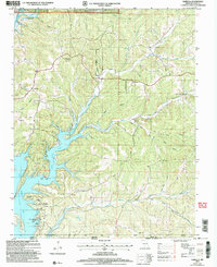
2004 Map of Isabella
USGS Topo · Published 2006About this map
Bull Shoals Lake dominates the southern landscape of this Ozark County region, where the winding arms of the reservoir reach deep into the Missouri hills. The map depicts a rugged interface between the protected lands of the Mark Twain National Forest and local settlements. The community of Isabella is situated in the northwest, while further south, the village of Pontiac serves as a gateway to the water with its boat ramps and the nearby Pontiac Cave. The terrain is characterized by a dense network of hollows, including Elm Hollow and Dover Hollow, which drain into the Little North Fork and South Fork. Genealogy interests are well-served by the presence of several established burial grounds such as Friend Cem, Wolf Cem, and Turnbull Cem, alongside the Pontiac Ch, marking the center of community life at the start of the millennium.
Find a feature on this map
39 named features on this map. Tap any name to fly to it.
Don’t see what you’re looking for? This feature index may not catch every label — zoom into the map to look around manually.
Map Details
Editions of this 2004 Isabella Map
This is the sole edition of this map. No revisions or reprints were ever made.
Other maps of this area

1890 · Mountain Home
USGS Topo · 1:125,000

1891 · Mountain Home
USGS Topo · 1:125,000

1893 · Yellville
USGS Topo · 1:125,000

1894 · Mountain Home
USGS Topo · 1:125,000

1903 · Yellville
USGS Topo · 1:125,000

1905 · Yellville
USGS Topo · 1:125,000

1929 · Yellville
USGS Topo · 1:125,000

1934 · Gainesville
USGS Topo · 1:48,000

1936 · Thornfield
USGS Topo · 1:48,000

1940 · Gainesville
USGS Topo · 1:62,500