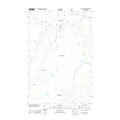
2013 Map of Isabella Station
USGS Topo · Published 2013About this map
Superior National Forest encompasses the entirety of this northern landscape, where the Stony River snakes through a complex network of glacial lakes and creek drainages. The small settlement of Isabella Station sits at the northern edge along State Hwy 1, serving as a primary access point for the region's forestry and recreation. The geography is punctuated by Stony Tower Hill, which reaches a peak at the Stony Lookout Tower, providing a strategic vantage point over the dense timber and waterways like Fishtrap Lake and Osier Lake. A series of forest routes, including Forest Rte 103 and Stony Loop Rd, create a primitive transportation grid through the backcountry. Remote outposts and landings, such as Jay See Landing and the location of Winter, reflect the area's sparse human footprint and its continued reliance on traditional forest access trails like the Snake Trl.
Find a feature on this map
40 named features on this map. Tap any name to fly to it.
Don’t see what you’re looking for? This feature index may not catch every label — zoom into the map to look around manually.
Map Details
Editions of this 2013 Isabella Station Map
This is the sole edition of this map. No revisions or reprints were ever made.
Other maps of this area

1953 · Whyte
USGS Topo · 1:62,500

1954 · Greenwood Lake
USGS Topo · 1:62,500

1954 · Silver Bay
USGS Topo · 1:62,500

1954 · Two Harbors
USGS Topo · 1:250,000

1955 · Isabella
USGS Topo · 1:62,500

1957 · Two Harbors
USGS Topo · 1:250,000

1958 · Two Harbors
USGS Topo · 1:250,000

1964 · Two Harbors
USGS Topo · 1:250,000

1976 · Two Harbors
USGS Topo · 1:100,000
1981 · Isabella
USGS Topo · 1:24,000