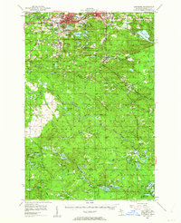
1952 Map of Ishpeming
USGS Topo · Published 1962About this map
Iron mining infrastructure dominates the landscape around Ishpeming and Negaunee in this mid-century survey. The northern half of the sheet is marked by the industrial footprints of the Tilden Mines, Tracy Mine, and New Volunteer Mine, connected by the extensive tracks of the Chicago and North Western railroad. Smaller residential clusters like Frenchtown, Salisbury, and Palmer appear tightly linked to these operations, while the Ishpeming City Boundary encompasses several prominent water bodies including Lake Angeline and Lake Bancroft. South of the urban centers, the terrain transitions into a more rural pattern characterized by features like the Finnish Ch and the Bakkala Cem in Forsyth. The presence of the Eleven Mile Grade and various gravel pits suggests a landscape defined by resource extraction and the logging-era transportation networks that preceded it.
Find a feature on this map
83 named features on this map. Tap any name to fly to it.
Don’t see what you’re looking for? This feature index may not catch every label — zoom into the map to look around manually.
Map Details
Editions of this 1952 Ishpeming Map
4 editions found
Other maps of this area

1907 · Marquette
USGS Topo · 1:62,500

1932 · Helena NW
USGS Topo · 1:31,680

1932 · Harvey NW
USGS Topo · 1:31,680

1932 · Harvey SW
USGS Topo · 1:31,680

1951 · Helena NW
USGS Topo · 1:31,680

1952 · Sands
USGS Topo · 1:24,000

1952 · Ishpeming
USGS Topo · 1:62,500

1952 · Ishpeming
USGS Topo · 1:24,000

1952 · Gwinn
USGS Topo · 1:62,500

1952 · Palmer
USGS Topo · 1:24,000