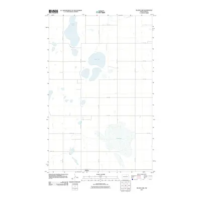
2011 Map of Island Lake
USGS Topo · Published 2011About this map
Wolford anchors the southern edge of this North Dakota prairie landscape, situated amidst a dense network of sectional roads and glacial wetlands. The geography is defined by a series of significant water bodies, most notably Island Lake, which sits centrally within the quadrangle. To the north, the elongated reach of Long Lake extends toward the margin, while the southern terrain is dominated by the broad expanse of Grass Lake.
Find a feature on this map
18 named features on this map. Tap any name to fly to it.
Don’t see what you’re looking for? This feature index may not catch every label — zoom into the map to look around manually.
Map Details
Editions of this 2011 Island Lake Map
This is the sole edition of this map. No revisions or reprints were ever made.
Other maps of this area

1953 · Devils Lake
USGS Topo · 1:250,000

1956 · Devils Lake
USGS Topo · 1:250,000

1971 · Wolford
USGS Topo · 1:24,000

1971 · Island Lake
USGS Topo · 1:24,000

1971 · Rugby NE
USGS Topo · 1:24,000

1971 · Mylo
USGS Topo · 1:24,000

1971 · Hurricane Lake West
USGS Topo · 1:24,000

1971 · Mylo NW
USGS Topo · 1:24,000
1971 · Rolette
USGS Topo · 1:24,000

1971 · Mylo SE
USGS Topo · 1:24,000