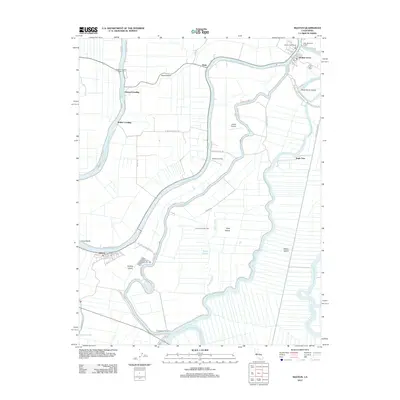
2012 Map of Isleton
USGS Topo · Published 2012About this map
The Sacramento River and its intricate network of sloughs define this section of the California Delta, where islands like Grand Island and Staten Island are bound by deep-water channels. The town of Isleton serves as a primary hub on Andrus Island, while Walnut Grove and Ryde sit further north along the river's winding course. This landscape is a hybrid of agricultural tradition and technical infrastructure, featuring the Delta Cross Channel and the River Island Gas Field. Transportation relies heavily on the water, evidenced by Landing Number 63 and the Howard Landing Ferry, which provides a vital link across Steamboat Slough. Smaller settlements like Walker Landing and Mathens Landing suggest the historic importance of river-based commerce and local logistics. Further inland on Tyler Island, the Spezia Airport and numerous rural roads like Poverty Rd illustrate how the reclaimed land was partitioned for industry and residency.
Find a feature on this map
53 named features on this map. Tap any name to fly to it.
Don’t see what you’re looking for? This feature index may not catch every label — zoom into the map to look around manually.
Map Details
Editions of this 2012 Isleton Map
This is the sole edition of this map. No revisions or reprints were ever made.
Other maps of this area

1894 · Lodi
USGS Topo · 1:125,000

1908 · Courtland
USGS Topo · 1:62,500

1910 · New Hope
USGS Topo · 1:31,680

1910 · Rio Vista
USGS Topo · 1:31,680

1910 · Bouldin
USGS Topo · 1:31,680

1910 · Jersey
USGS Topo · 1:31,680

1910 · Bruceville
USGS Topo · 1:31,680

1910 · Headreach
USGS Topo · 1:31,680

1910 · Isleton
USGS Topo · 1:31,680

1916 · Cache Slough
USGS Topo · 1:31,680