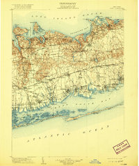
1904 Map of Islip
USGS Topo · Published 1920About this map
Long Island Railroad corridors define the development of central Suffolk County, with the Main Line and Montauk Division carving paths through a landscape of coastal harbors and interior heights. The northern shore is deeply indented by maritime features like Huntington Bay and Port Jefferson Harbor, while the interior rises into the Dix Hills and Half Hollow Hills. Prominent social and institutional landmarks of the era are visible, including the St. Dominic Convent near the western boundary and the expansive State Hospital grounds near Kings Park.
Find a feature on this map
161 named features on this map. Tap any name to fly to it.
Don’t see what you’re looking for? This feature index may not catch every label — zoom into the map to look around manually.
Map Details
Editions of this 1904 Islip Map
5 editions found

Other maps of this area

1891 · Bridgeport
USGS Topo · 1:62,500

1892 · Stamford
USGS Topo · 1:62,500

1892 · Norwalk
USGS Topo · 1:62,500

1893 · Bridgeport
USGS Topo · 1:62,500

1893 · Stamford
USGS Topo · 1:62,500

1893 · Norwalk
USGS Topo · 1:62,500

1897 · Hempstead
USGS Topo · 1:62,500

1897 · Oyster Bay
USGS Topo · 1:62,500

1898 · Hempstead
USGS Topo · 1:62,500

1898 · Oyster Bay
USGS Topo · 1:62,500