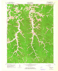
1962 Map of Isonville
USGS Topo · Published 1964About this map
The Little Sandy River and its complex network of forks carve through the deeply dissected landscape of Elliott County in this 1962 revision. Small rural settlements like Isonville and Sandy Hook anchor the community, connected by winding valley roads that follow the path of least resistance through the hills. The map captures a moment of local extraction, documented by numerous Oil Wells and Gas Wells scattered along the Right Fork and throughout the Left Fork drainage areas. Local life is represented by the Isonville Sch, the Roscoe Sch, and Fraley Chapel. The ruggedness of the terrain is evident in the naming of isolated places such as Shanty Hollow and Zach Rice Hollow, while the Lookout Tower on Peters Hill provides a vantage point over the dense forest and the Elliott and Morgan County boundary line.
Find a feature on this map
65 named features on this map. Tap any name to fly to it.
Don’t see what you’re looking for? This feature index may not catch every label — zoom into the map to look around manually.
Map Details
Editions of this 1962 Isonville Map
3 editions found
Other maps of this area

1886 · Prestonsburg
USGS Topo · 1:125,000

1889 · Salyersville
USGS Topo · 1:125,000

1891 · Salyersville
USGS Topo · 1:125,000

1892 · Prestonsburg
USGS Topo · 1:125,000

1899 · Salyersville
USGS Topo · 1:125,000

1903 · Kenova
USGS Topo · 1:125,000

1904 · Kenova
USGS Topo · 1:125,000

1915 · Paintsville
USGS Topo · 1:48,000

1917 · Paintsville
USGS Topo · 1:62,500

1950 · Bruin
USGS Topo · 1:24,000