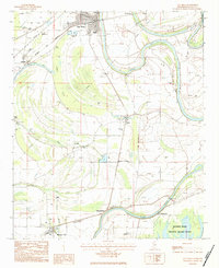
1983 Map of Itta Bena
USGS Topo · Published 1984About this map
The Columbus and Greenville railroad corridor anchors the northern reaches of this Mississippi Delta landscape, serving the community of Itta Bena and the surrounding agricultural tracts. The terrain is defined by the complex hydrology of the Yazoo River and its associated backwaters, including the prominent oxbow of Roebuck Lake and the wetlands of the Mathews Brake National Wildlife Refuge. These water bodies and brakes historically dictated the patterns of settlement and transport before the modern era of drainage.
Find a feature on this map
35 named features on this map. Tap any name to fly to it.
Don’t see what you’re looking for? This feature index may not catch every label — zoom into the map to look around manually.
Map Details
Editions of this 1983 Itta Bena Map
This is the sole edition of this map. No revisions or reprints were ever made.
Other maps of this area

1931 · Schlater
USGS Topo · 1:48,000

1934 · Schlater
USGS Topo · 1:62,500

1936 · Greenwood
USGS Topo · 1:62,500

1939 · Schlater
USGS Topo · 1:62,500

1940 · Seven Pines
USGS Topo · 1:62,500

1940 · Greenwood
USGS Topo · 1:62,500

1953 · Greenwood
USGS Topo · 1:250,000

1956 · Greenwood
USGS Topo · 1:250,000

1957 · Greenwood
USGS Topo · 1:62,500

1957 · Seven Pines
USGS Topo · 1:62,500