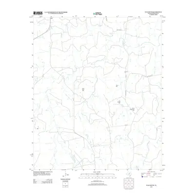
2012 Map of Ivan South
USGS Topo · Published 2012About this map
Ivan sits at the northern edge of this landscape in Stephens County, Texas, serving as a focal point for a region defined by its prominent limestone and sandstone elevations. The terrain is marked by a series of named peaks that likely influenced early navigation and ranching boundaries, including Lime Rock Mtn, Coon Mtn, and the curiously named Devils Reservation Mtn. These summits rise above a network of seasonal drainages such as Sandy Cr, Cedar Cr, and Caddo Cr, which carve through the plains. Local history is anchored at the Bee Branch Cem near the center of the map, situated along FM 3253. The layout of rural routes like FM 717 and various county roads indicates a persistent pattern of land use centered on ranching and scattered rural homesteads, where the natural topography of the Texas Cross Timbers dictates the placement of roads and settlement pockets.
Find a feature on this map
22 named features on this map. Tap any name to fly to it.
Don’t see what you’re looking for? This feature index may not catch every label — zoom into the map to look around manually.
Map Details
Editions of this 2012 Ivan South Map
This is the sole edition of this map. No revisions or reprints were ever made.
Other maps of this area

1890 · Breckenridge
USGS Topo · 1:125,000

1924 · Breckenridge 1-a
USGS Topo · 1:48,000

1924 · Breckenridge 1-d
USGS Topo · 1:48,000

1925 · Breckenridge 1-b
USGS Topo · 1:48,000

1931 · Ivan
USGS Topo · 1:62,500

1954 · Abilene
USGS Topo · 1:250,000

1958 · Abilene
USGS Topo · 1:250,000

1967 · Necessity
USGS Topo · 1:24,000
1967 · Grand Lake
USGS Topo · 1:24,000
1967 · Brad
USGS Topo · 1:24,000