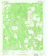
1967 Map of Ivan South
USGS Topo · Published 1970About this map
The rugged landscape of northern Stephens County is dominated by the sprawling oil and gas fields of the mid-1960s, punctuated by distinctive topographic peaks such as Devils Reservation Mountain and Bee Branch Mountain. The small community of Ivan anchors the northwest corner of the sheet, while the rural interior is defined by a dense network of Oil Wells and a central Pipeline corridor. Significant local landmarks for genealogists and historians include the Oak Grove Ch and the remote Bee Branch Cem located near the base of Coon Mtn. The terrain is deeply dissected by numerous watercourses, including the meandering paths of Cedar Creek, Sandy Creek, and Caddo Creek, illustrating the complex drainage patterns that influenced settlement and industrial access in this portion of the Texas plains.
Find a feature on this map
22 named features on this map. Tap any name to fly to it.
Don’t see what you’re looking for? This feature index may not catch every label — zoom into the map to look around manually.
Map Details
Editions of this 1967 Ivan South Map
This is the sole edition of this map. No revisions or reprints were ever made.
Other maps of this area

1890 · Breckenridge
USGS Topo · 1:125,000

1924 · Breckenridge 1-a
USGS Topo · 1:48,000

1924 · Breckenridge 1-d
USGS Topo · 1:48,000

1925 · Breckenridge 1-b
USGS Topo · 1:48,000

1931 · Ivan
USGS Topo · 1:62,500

1954 · Abilene
USGS Topo · 1:250,000

1958 · Abilene
USGS Topo · 1:250,000

1967 · Necessity
USGS Topo · 1:24,000
1967 · Grand Lake
USGS Topo · 1:24,000
1967 · Brad
USGS Topo · 1:24,000