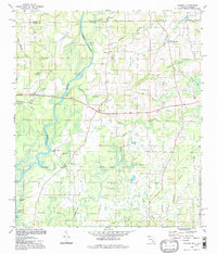
1994 Map of Izagora
USGS Topo · Published 1998About this map
The Choctawhatchee River and its meandering western banks define this rural stretch of the Alabama-Florida border. In the late 20th century, the landscape remains primarily defined by small crossroad settlements and a network of country churches, including Midway Ch, Mt Ida Ch, and New Zion Ch. The transition between Geneva County, Alabama, and Holmes County, Florida, is marked by distinctive water features like Alberson Stretch and the Widewater. Local history is anchored at sites such as Curry Ferry and several family-named landmarks like Smith Crossroads and Pittman. The presence of Blackfish Lake, Chapman Lake, and Blue Lake in the southern reaches highlights the low-lying, water-rich terrain of the Florida Panhandle's northern edge.
Find a feature on this map
42 named features on this map. Tap any name to fly to it.
Don’t see what you’re looking for? This feature index may not catch every label — zoom into the map to look around manually.
Map Details
Editions of this 1994 Izagora Map
This is the sole edition of this map. No revisions or reprints were ever made.
Other maps of this area

1942 · Enterprise
USGS Topo · 1:125,000

1949 · Hobbs Crossroads
USGS Topo · 1:24,000

1949 · Caryville
USGS Topo · 1:24,000

1950 · Hobbs Cross Roads
USGS Topo · 1:24,000

1950 · Prosperity
USGS Topo · 1:24,000

1950 · Caryville
USGS Topo · 1:24,000

1950 · Izagora
USGS Topo · 1:24,000

1950 · Esto
USGS Topo · 1:24,000

1951 · Esto
USGS Topo · 1:24,000

1951 · Bonifay
USGS Topo · 1:24,000