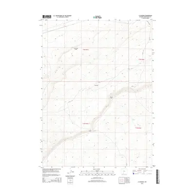
2015 Map of J O Dugway
USGS Topo · Published 2015About this map
The Continental Divide winds through this high-desert portion of Sweetwater County, shaping a landscape defined by significant topographic shifts and remote ranching access. Central to the area is the J O Dugway, a critical passage through the steep elevation change of the Delaney Rim. This landform serves as a dramatic natural barrier, with the lower elevations to the south containing water sources like Delaney Spring and J O Spring. The presence of the Red Wash drainage and various Bureau of Land Management routes, such as BLM 4410, illustrates the infrastructure required to navigate this portion of the Red Desert. This survey provides a clear view of the transition from the high plateau down into the basin, where old access roads like Tipton Station Rd connect the isolated interior to distant rail corridors.
Find a feature on this map
15 named features on this map. Tap any name to fly to it.
Don’t see what you’re looking for? This feature index may not catch every label — zoom into the map to look around manually.
Map Details
Editions of this 2015 J O Dugway Map
This is the sole edition of this map. No revisions or reprints were ever made.
Other maps of this area

1954 · Rock Springs
USGS Topo · 1:250,000

1958 · Rock Springs
USGS Topo · 1:250,000

1962 · Rock Springs
USGS Topo · 1:250,000

1970 · Red Desert SW
USGS Topo · 1:24,000

1970 · Table Rock
USGS Topo · 1:24,000

1970 · Red Desert NW
USGS Topo · 1:24,000

1970 · J O Dugway
USGS Topo · 1:24,000

1970 · Fort La Clede NE
USGS Topo · 1:24,000

1970 · Tipton
USGS Topo · 1:24,000
1970 · Haystack Flats
USGS Topo · 1:24,000