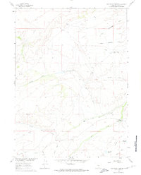
1961 Map of Jack Creek Reservoir
USGS Topo · Published 1974About this map
The Continental Divide defines the high-altitude hydrology of this Carbon County landscape, where the management of water is central to the high-plains ranching economy. This 1961 field-checked survey highlights the sophisticated irrigation and storage systems required for survival, including the Jack Creek Reservoir and the Buck Draw Reservoir. These artificial water bodies are supported by significant engineering works like the Jack Creek Ditch and the Seaverson Ditch, designed to move water across the arid terrain. Ranching life is anchored by established homesteads such as the Lazy Cj Jack Creek Ranch and Boden Ranch. The landscape is etched with complex drainage systems, from the branching First Cottonwood Draw to the seasonal flow of Beaver Creek and Little Jack Creek, providing a detailed look at how high-desert water rights shaped the physical and social geography of the region.
Find a feature on this map
22 named features on this map. Tap any name to fly to it.
Don’t see what you’re looking for? This feature index may not catch every label — zoom into the map to look around manually.
Map Details
Editions of this 1961 Jack Creek Reservoir Map
2 editions found

Other maps of this area

1893 · Fort Steele
USGS Topo · 1:125,000

1932 · Savery
USGS Topo · 1:96,000

1939 · Saratoga
USGS Topo · 1:125,000

1940 · Savery
USGS Topo · 1:125,000

1954 · Rawlins
USGS Topo · 1:250,000

1955 · Overland Crossing
USGS Topo · 1:24,000

1956 · Bolten Ranch
USGS Topo · 1:62,500

1958 · Rawlins
USGS Topo · 1:250,000

1961 · Divide Peak
USGS Topo · 1:24,000

1961 · Middlewood Hill
USGS Topo · 1:24,000