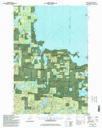
1996 Map of Jack Lake
USGS Topo · Published 1998About this map
The Leech Lake Indian Reservation and Chippewa National Forest converge in this mid-1990s record of north-central Minnesota's lake country. The map showcases a dense network of inland waters and wetlands, with the southern shoreline of Leech Lake dominating the northern half. Notable landforms include Rogers Point, Pelican Island, and Pipe Island, which define the intricate interface between land and water. Cultural and historical landmarks are scattered throughout the wooded terrain, including the Medicine Rite Cem and Hope Cemetery.
Find a feature on this map
35 named features on this map. Tap any name to fly to it.
Don’t see what you’re looking for? This feature index may not catch every label — zoom into the map to look around manually.
Map Details
Editions of this 1996 Jack Lake Map
This is the sole edition of this map. No revisions or reprints were ever made.
Other maps of this area

1953 · Brainerd
USGS Topo · 1:250,000

1954 · Bemidji
USGS Topo · 1:250,000

1957 · Brainerd
USGS Topo · 1:250,000

1957 · Bemidji
USGS Topo · 1:250,000

1958 · Bemidji
USGS Topo · 1:250,000

1958 · Brainerd
USGS Topo · 1:250,000

1965 · Brainerd
USGS Topo · 1:250,000

1970 · Hackensack
USGS Topo · 1:24,000

1970 · Webb Lake
USGS Topo · 1:24,000

1970 · Woman Lake
USGS Topo · 1:24,000